Visitors can check out the Forum FAQ by clicking this link. You have to register before you can post: click the REGISTER link above to proceed. To start viewing messages, select the forum that you want to visit from the selection below. View our Forum Privacy Policy.
Want to receive the latest contracting news and advice straight to your inbox? Sign up to the ContractorUK newsletter here. Every sign up will also be entered into a draw to WIN £100 Amazon vouchers!
You are not logged in or you do not have permission to access this page. This could be due to one of several reasons:
You are not logged in. If you are already registered, fill in the form below to log in, or follow the "Sign Up" link to register a new account.
You may not have sufficient privileges to access this page. Are you trying to edit someone else's post, access administrative features or some other privileged system?
If you are trying to post, the administrator may have disabled your account, or it may be awaiting activation.
Logging in...
Previously on "Who said AGW wasn't pushing science forwards?"
Just because the earth is fatter at the equator it doesn't necessarily follow that it is more dense.
true, the Earth is fatter at the equator because the net force squeezing the earth into a sphere is less there, because centrifual force is greater at the equator, though gravitational anomalies (because as you say density variations amongst other things) are bound to exist.
I don't quite get what it is being shown there. Yellow and mountains indicating less gravity? I had expected a tendency for surface gravity to indicate less nearer the equator and greater at the poles, on average (as per the shape of the earth).
Just because the earth is fatter at the equator it doesn't necessarily follow that it is more dense.
I don't quite get what it is being shown there. Yellow and mountains indicating less gravity? I had expected a tendency for surface gravity to indicate less nearer the equator and greater at the poles, on average (as per the shape of the earth).
Gravity field mapping, ion drive propulsion... pretty pictures...
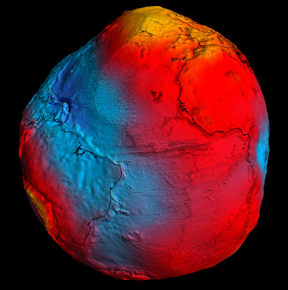
The European Space Agency today unveiled a new gravity map of Earth put together using data from its Gravity Field and Steady-State Ocean Circulation Explorer (GOCE) satellite.
The "geoid" represents "the surface of an ideal global ocean in the absence of tides and currents, shaped only by gravity", ESA explains, adding: "It is a crucial reference for measuring ocean circulation, sea-level change and ice dynamics – all affected by climate change."
")
Leave a comment: